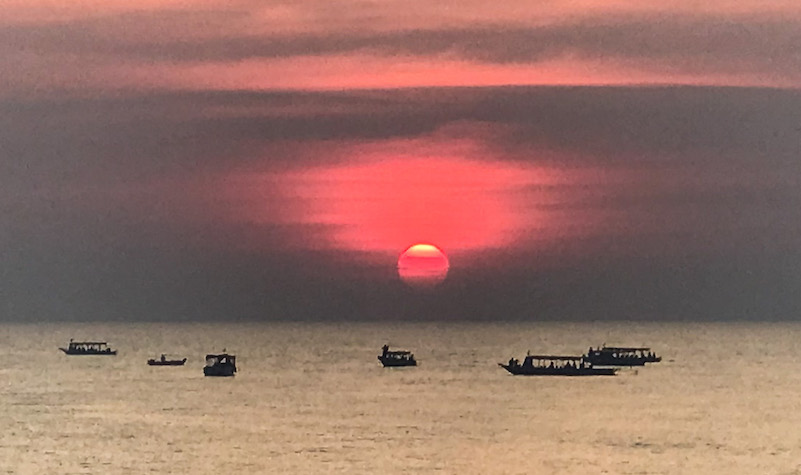
Excursion boats in Tonlé Sap, Southeast Asia’s largest lake, watch the sunset in the western sky. Photo by John Gottberg Anderson
By John Gottberg Anderson
I had crocodile for dinner the other night.
Not the whole thing, of course. Even a relatively small adult croc could feed a Cambodian village for a week. But fileted and stir-fried with aromatic lemongrass, onions, garlic and spicy red chilies — served with steamed white rice and a cold beer — it tasted not unlike pork that may have been barbecued just a little too long.
The setting of my meal was appropriate: I was seated on planks atop a crude barge that floated near the shore of 150-mile-long Tonlé Sap. Southeast Asia’s largest lake is a notorious domicile for both the Siamese crocodile and the voracious saltwater crocodile, the world’s largest reptile. Up to 20 feet long and weighing more than a ton, it has vise-like jaws that devour fish, birds and small farm animals in less time than it takes to clap one’s hands.
Sunset on the placid waters was impressive, the yellow-orange sun falling gently through hazy clouds to meet the lake on the distant horizon with a whisper. A small flotilla of boats had gathered to observe the spectacle.
But I had only one eye on the panorama. My other was focused on a prehistoric creature, dark gray-green in color. Its heavily armored spine would have made old Stegosaurus proud. Black, talon-like claws and a spiked mace of a tail left me wondering if it might soon get medieval on someone.
I hoped it wasn’t me. Thank God, the crocodile was caged. I was, after all, cannibalizing its kin.
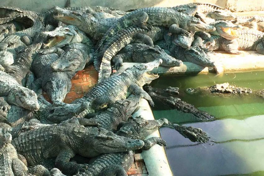
Saltwater crocodiles crawl atop one another at a crocodile farm on Tonlé Sap, near the city of Battambang. Photo by Ananth Baliga, Phnom Penh Post
A Summer Surge
During the dry season in the first two months of the year the Tonlé Sap (“Great Lake”) barely has enough water to warrant wearing galoshes. A river drains the lake, carrying its flow to the Mekong River and out to the South China Sea. In summer and autumn, however, it’s a very different place. Monsoon rains from the Tibetan Plateau pour into the Mekong. When it reaches the Cambodian capital of Phnom Penh an overflow backs up the tributary Tonlé Sap River, reversing its current for 75 miles to the lake.
As a result, waters no deeper than 3 to 4 feet in the dry period surge dramatically. By summer, and especially in September and October, the Tonlé Sap’s depth may reach 30 to 35 feet as it pours over thousands of square miles of flood plain. Dense mangrove forests around the lakeshore become prime crocodile habitat as well as important fishing grounds. After months of subsisting on such endemic fish as featherbacks and tiny mud carp, villagers can now cast their seine nets for more substantial catfish and the toothy species known as snakehead murrel. That is, if the crocs don’t beat them to it.
But the times are changing. The wetlands, which extend across more than 6,000 square miles, support a remarkable biodiversity of flora and fauna, including many rare or endangered animals. For more than two decades, the UNESCO-monitored Tonlé Sap Biosphere Reserve has focused on conservation, education and development, especially with regard to villages around the lakeshore. But conservation and development can be diametrically opposed. Poor villagers often cut the flooded forest and dig canals for dry season farming, and in doing so deplete resources that support the aquatic environment. The number of large fish caught from the lake has declined significantly. Even crocodiles’ numbers are rapidly diminishing, although floating farms operate on the west side of the lake, nearer to Battambang than to Siem Reap.
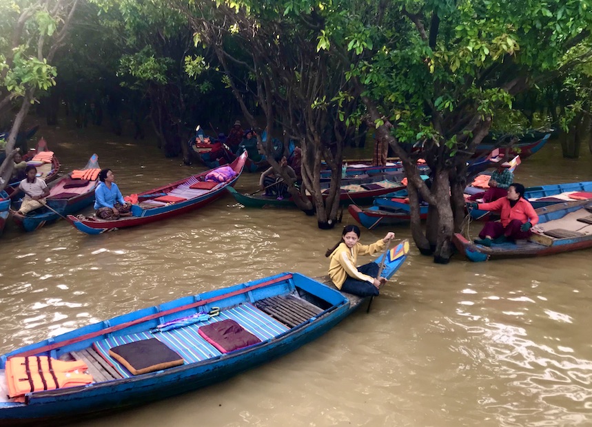
Women from Tonlé Sap’s “floating” villages paddle canoes through the mangrove forests along the lake shore. Tourists may book visits to the hamlets from the city of Siem Reap and hire a boat for further exploring. Photo by John Gottberg Anderson
Kampong Phluc
The village of Kampong Phluk is no more than 2 miles upstream from the mouth of the Siem Reap River at Tonlé Sap. Children were everywhere in evidence during my brief visit. My traveling companions, a Belgian couple in their 60s, bought some pencils and notebooks from vendors outside the one-room schoolhouse. They were encouraged to make a formal donation to the class. Even the small number of tourists who stray from the well-trodden track to Angkor Wat to visit this rural outpost seem to make a difference in the villagers’ lives.
The school is on set upon a bluff, near the Buddhist temple that is the community center for Kampong Phluc. The temple was built high enough on the hill that a few steps are all that is needed to enter the vihara, the prayer hall where villagers bow low to the ground before a larger-than-life, technicolor image of the Buddha. Wisps of incense invade their sinuses from sticks that smolder in small pots before the altar. True to Theravada tradition, the founder of the faith is revered as a teacher rather than a god. Cartoon-like panels on walls and ceiling tell legends of the Buddha’s life, bringing distracted parishioners back to their reason for being here.
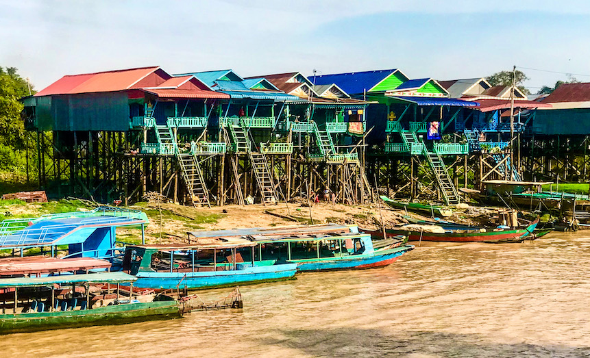
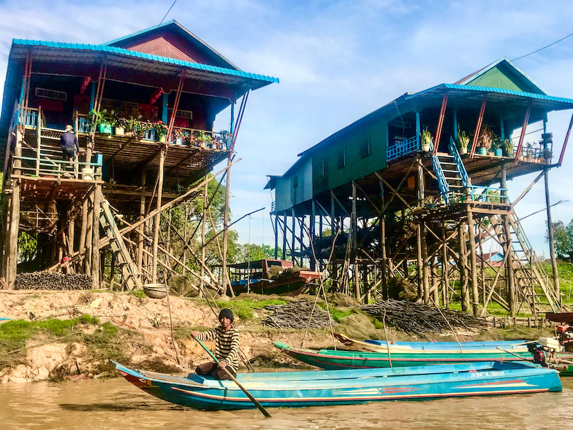
Village houses like these in Kampong Phluc are built on scaffolding 30 feet above the ground to compensate for an annual rise in the level of nearby Tonlé Sap. Photo by John Gottberg Anderson
Sights and smells
Elevation is important in the village, as nearly every structure is built on stilts. In the wet season, Kampong Phluk’s nearly 4,000 residents can step out of their extended-family homes onto their boats, the only dependable form of transportation during the wet season. But come February, residents who are not careful can experience a hard 30-foot drop to the ruddy clay below. As I studied the abodes — first looking up from a boat on the river, then across the stream and down from the temple — I was fascinated to imagine them as a floating village, which is surely how they must appear when the lake and, thus, the river, are at their full volume.
Now, however, the river was barely deep enough to contain the shallow-draft vessels that followed its S-shaped course through the settlement. My low wooden boat, its once-bright aquamarine pigment faded from many seasons of use, docked beside a rickety pier. My cohorts and I took the opportunity to kick up the red dust of clay “roads” as we took in the sights, smells and sounds of the village. Beneath the scaffolding that supported the residences, men repaired their nets, old women mended fish traps, younger women grilled fish, children raced around with other children, and dozens of mid-sized dogs, their common ancestry apparent, yipped in delight. Not a lot of English was spoken but smiles and waves were in abundance.
Homeowners tie their boats to their decks in the wet season, but in the dry season during the early months of the year they must walk down to their vessels tied to the bank of the river. Photo by John Gottberg Anderson
Floating villages
Kampong Phluc is only one of several so-called “floating villages” along the shore of Tonlé Sap. (Kampong Phluc is most easily visited because of its proximity to the tourist center of Siem Reap). All are communities in transition. Today, as climate change threatens the seasonal cycles, tourism is altering villagers’ views of how they and their children might someday earn incomes. And in this basin, a surfeit of hydropower projects upriver in China, Laos and even Cambodia is dramatically altering the water schedule.
Struggles are perhaps nowhere as evident as in the perpetually floating villages of Vietnamese nationals, living in a watery purgatory since the atrocities of the Khmer Rouge era of the 1970s. As many as 8,000 reside at Tonlé Sap, migrating with the waters into tributary rivers or swamp forests. Rejected by Vietnam and barely tolerated by Cambodia, they are citizens of neither country.
Perhaps some relief will be afforded by the continued growth of Siem Reap as a tourist gateway to the UNESCO World Heritage site of Angkor. Now Cambodia’s second-largest city with a quarter-million people, Siem Reap has a similar number of hotel rooms in all price ranges. It has upscale international restaurants and tiny Khmer street stalls, a bustling nightlife along midtown Pub Street, and a quiet little river that flows past colorful Buddhist temples and traditional markets. A recent flush of Chinese investment in Cambodia will yield a new international airport by early next year (or sooner), along with a wave of showy resort communities.
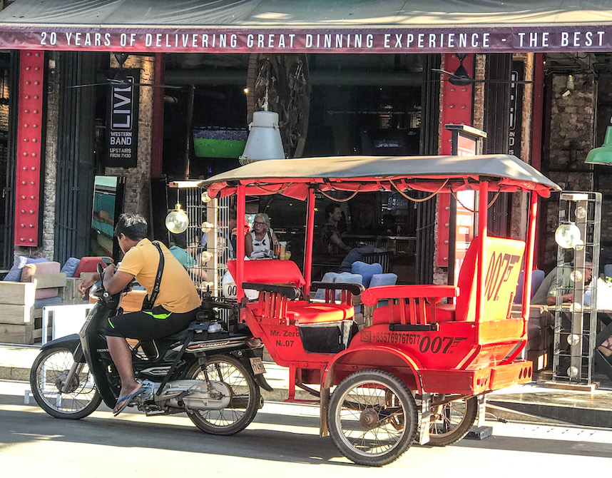
Modern tuk tuks, are shaded wagons hitched to motorbikes. They often are gaily painted to reflect their owners’ personalities. They travel between Siem Reap and Angkor Wat. Photo by John Gottberg Anderson
No Angst at Angkor
The monuments of Angkor owe their restoration largely to the UNESCO-supported international community, and to a tourist infrastructure that supported an estimated 2.5 million visitors per year as recently as 2019. Today, most ruins are protected within Angkor Archaeological Park, which offers tickets for visits of one, three and seven days. A specialized academy trains multilingual guides, more than 500 of whom serve the park. And each day, a fleet of vehicles — from three-wheeled tuk tuks to tourist buses — shuttles guests 4 miles from Siem Reap to Angkor Wat, the world’s single largest religious structure.
Nine centuries ago, Angkor Wat was the hub of one of the world’s largest cities. Remnants of more than 1,000 temples spread across 400 square miles of jungle-dominated northwestern Cambodia. But tourism focuses primarily on the temples nearest Siem Reap. In addition to Angkor Wat, these include Angkor Thom and its central Bayon temple, famed for its intricate bas-relief art; Ta Prohm, the so-called Tomb Raider temple, a popular film location partially overgrown by jungle; Preah Khan, a medieval university; and tiny but elegant Binteay Srey, a bucolic agricultural district 16 miles outside of the central Angkor complex that offers guided jungle walks and ox-cart rides.
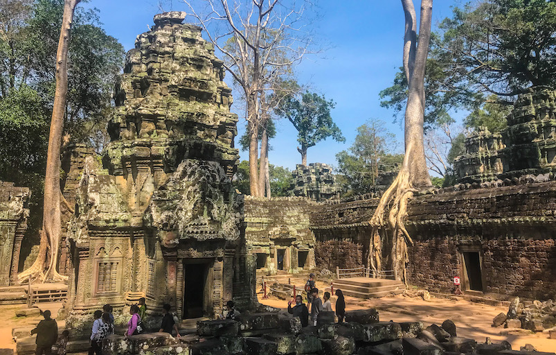
Giant kapok trees have planted themselves in Ta Prohm, built in the 12th century as a Buddhist university. Photo by John Gottberg Anderson
Ubiquitous in sandstone carvings on temple facades is one particular animal: the crocodile. Indeed, in friezes depicting aquatic battle scenes, the great reptiles are shown devouring the bodies of enemies driven from their boats. It reminded me of an ancient horror movie, long before film was invented.
Full disclosure: Dining on crocodile, I felt a part of that history. Turnaround is fair play, am I right?![]()
East-West News Service Contributor John Gottberg Anderson recently wrote about Tét, Vietnam’s lunar new year holiday and the Áo Dài, the elegant dress worn by Vietnamese women
1 Comment